Tornadoes: The Most Terrifying Twisters Caught On Video And The Science Behind Them
Few forces of nature have the awesome destructive power of a tornado.
This article is more than 2 years old
Few forces of nature have the awesome destructive power of a tornado. Sure, an earthquake or hurricane, among other disasters, may have a broader, more widespread impact, but as far as sheer pinpoint devastation goes, a twister is hard to beat. But what makes them tick?
How do tornadoes form? What conditions are necessary for them to come alive? How accurate are movies like Twister when it comes to what really goes on with these storms that are so much more terrifying than any monster our imagination can come up with?
Tennes Couple Survives Inside Their House While It’s Sucked Up By A Tornado
The deadliest tornado outbreak in 7-years hit Putnam County, Tennessee in early March of 2020. The storms left 25 people dead and dozens missing in their wake.
Two residents who survived to tell the tale are Seth Wells and Danielle Theophile. They describe being inside their house while it was sucked up inside a tornado, and then dashed to pieces against a group of trees.
Here’s their incredible story…
Welles explains that the couple took refuge in their bathtub, but then bathtub, house and all were lifted off the ground. He says, “We were flying in the air, into the trees back there, where once we hit those trees, the house… it just exploded. The house just disintegrated” They could feel themselves flipping over and over, like the famous scene straight out of the Wizard of Oz.
What Are Tornadoes?
We’ve all seen footage of tornadoes that look like focused tunnels of powerful winds. And that’s essentially what they are. According to the National Weather Service, a tornado is defined as:
“A violently rotating column of air touching the ground, usually attached to the base of a thunderstorm.”
Categories of Tornadoes
Much like hurricanes, the intensity of tornadoes is measured on a scale. It can be difficult to accurately determine the wind speed, but researchers classify them on the Enhanced Fujita Scale, which breaks down into six categories based on strength and related damage.
- EF0: Wind speeds of 65-85 mph. Light damage, including broken branches, shallow-rooted trees being toppled, and damage to signs and chimneys.
- EF1: Wind speeds of 86-110 mph. Moderate damage, including roofs peeled off of houses, moving cars pushed off the road, and mobile homes pushed off of foundations or toppled completely.
- EF2: Wind speeds of 111-135 mph. Considerable damage, including roofs torn off homes, toppled boxcars, demolished mobile homes, large uprooted trees, and light items becoming projectiles.
- EF3: Wind speeds of 136-165 mph. Severe damage, like cars being lifted and thrown, forests flattened, trains toppled, and roofs and walls torn off of well-built houses.
- EF4: Wind speeds of 166-200 mph. Devastating damage. This includes houses flattened, destroyed, or even being torn from their foundations and flung a great distance; large projectiles; and cars tossed around by the wind.
- EF5: Wind speeds of 200+ mph. Incredible damage. This can include trees being stripped of their bark, cars becoming projectiles, and houses torn off foundations and thrown a great distance.
The National Weather Service uses a 28-point scale of damage indicators to assign each storm an official EF rating.
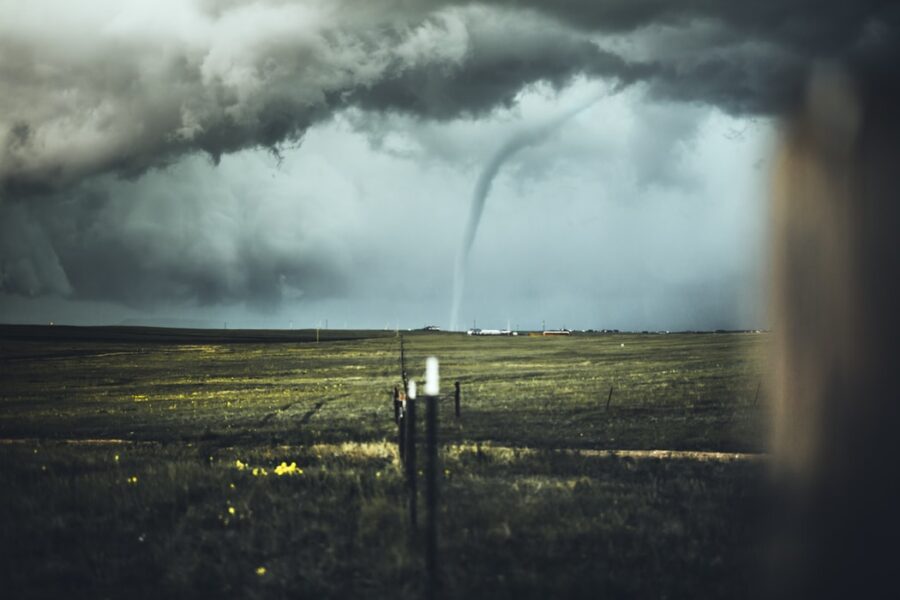
Incredible Twisters Caught On Video
Before we dig deeper into the science behind these destructive storms, you should see what we’re talking about. Be warned, some of these videos are incredibly frightening.
First up is perhaps the best tornado video ever captured. It happened near Wray, Colorado in 2016 and it’s hard to watch this without shouting “too close too close” at your monitor. Here you go…
This F5 tornado hit Joplin Missouri in May of 2011. Watch it wreak havoc…
The video below shows off a huge, terrifying F5 tornado caught on video in Tuscaloosa, Alabama…
This next video gives you a look at a full on F5 tornado. It happened on May 3, 1999 and the people in it make a LOT of mistakes including taking shelter under an overpass. Never do this…
The video below shows a Wedge type tornado captured in Manitoba, Canada on June 23 of 2007. Storm chasers Reed Timmer and Dave Holder are only 200 yards away from it when it crosses the road right in front of them…
What follows is one of several tornadoes captured on film during a June 24, 2003 series of storms in South Dakota. The tornado you’re about to see is a 1/4 mile wide F4 and it’s only a few hundred yards away from the cameraman…
In this amazing video, storm chasers were able to be at the exact point where the tornado starts to form, before it touches the ground. As you’ll see in the video, the tornado forms from the ground up, stretching up from the dirt into the clouds. Incredible. Watch…
How Tornadoes Form
Tornadoes appear in many forms—big and small, cones and wedges and ropes, to name few. While we usually associate them with a certain geographical region of the American Midwest, often called Tornado Alley, they’ve been reported in all 50 states. (In 2018, there was a destructive storm near my home town in Washington.)
Tornadoes begin with a thunderstorm, but a specific type called a supercell, which requires specific weather conditions to get going.
A supercell is a towering thunderstorm identified by the presence of deep, persistently rotating updrafts—these updrafts are also called Mesocyclones. These storms often occur when warm, moist air meets cool, dry air. The former coming up from the Gulf of Mexico running into the latter on the way down from Canada, is a big reason why Tornado Alley is such a hotbed of activity.
When the two collide, a number of things happen. They generate volatility in the atmosphere, which leads to huge drafts of rising air. A change in wind direction and windspeed leads to spinning winds lower in the atmosphere. High, fast-moving air essentially rolls over slower air below, which causes a kind of cylindrical horizontal wind tube. Updrafts of rising air tilt the spinning air vertically and create a vortex.
Downdrafts of cooler air within the supercell then push this column toward the ground. If this spinning air becomes focused and forms a powerful column of rotating air, and hits the ground, it’s a tornado.
Whether or not a tornado forms depends on the situation. Conditions that lead to one tornado, may not always lead to another. They also usually involve the presence of hail and lightning. These outbursts can form quickly, but while most are short-lived, some last more than an hour.
Tornadoes dissipate for a number of reasons. When weather conditions stabilize and the temperature difference disappears, or when the moisture in the air starts to dry up, storms lose momentum.
Types Of Twisters
While we often talk about tornadoes as a single category of storm, there are, within that larger grouping, smaller subsets and types. Every storm is unique and different, but they each fall into a broader type based on factors like size, shape, and how they form.
Rope Tornado
When you think of a tornado, the first image that comes to mind is likely a tall, relatively slender column of air extending from the ground to the clouds. (At least that’s where my brain goes—then again, I’ve never seen one in real life or lived in an area where they’re common.) This is a rope tornado.
These are the smallest type of tornadoes. In fact, larger storms usually begin and end their lifecycle as rope tornadoes, though some never progress beyond this stage. Still, even with their more diminutive stature, these remain dangerous and destructive.
Cone Tornado
A cone tornado takes its name from its distinctive shape. They are quite wide at the top where they meet their thunderstorm but narrow at the base where they touch the ground. Some, usually called stovepipe tornadoes, are roughly the same width at the bottom as they are at the top.
In general, cone tornadoes are significantly larger and more destructive than rope tornadoes. They tend to leave wider swaths of destruction in their wake, have a longer lifespan, and be more dangerous overall.
Wedge Tornadoes
The largest, deadliest, and most destructive of these storms tend to fall into the category of wedge tornadoes. They’re relatively the same shape as cone tornadoes—wide at the top, narrow at the bottom—only much larger and more exaggerated. It’s not uncommon for one of these storms to be wider than they are tall, and they’re usually at least half a mile wide.
We’re talking about major storms here. Because of this size, they usually cause the most damage and most rate at least EF3 on the Enhanced Fujita Scale. In 2013, the El Reno Tornado tore through Oklahoma and left a 2.6-mile-wide path of ruin. It was a wedge tornado.
Multi-Vortex and Satellite Tornadoes
A single storm can produce multiple tornadoes over its lifespan, though usually not at the same time. However, some storms do produce several simultaneously. Which sounds terrifying.
A multi-vortex tornado is one that has multiple vortices swirling around a single storm. Think a smaller tornado spinning around a larger one. In most cases, after they’ve formed, the storms aren’t visually distinguishable from one another, though they can enhance the overall intensity of the main storm. The El Reno Tornado was also a multi-vortex storm.
In some cases, though it’s less common, instead of a bigger tornado with a few smaller offshoots, two tornadoes of relatively similar size and intensity can form. This is called a satellite tornado. They come from the same storm and same mesocyclone but are essentially two individual tornadoes. As you might imagine, this often causes major destruction.
Non-Supercell Tornadoes
Not all tornadoes are born from supercell storms. There are non-supercell tornadoes. These form from a vertical column of air spinning near the ground instead of a big storm. They’re caused by wind shear when cold air meets with warmer air. If an updraft comes into contact with this, it may form a tornado. This happens often in Colorado, where cool air coming down from the Rockies encounters warm, dry air moving in from the plains.
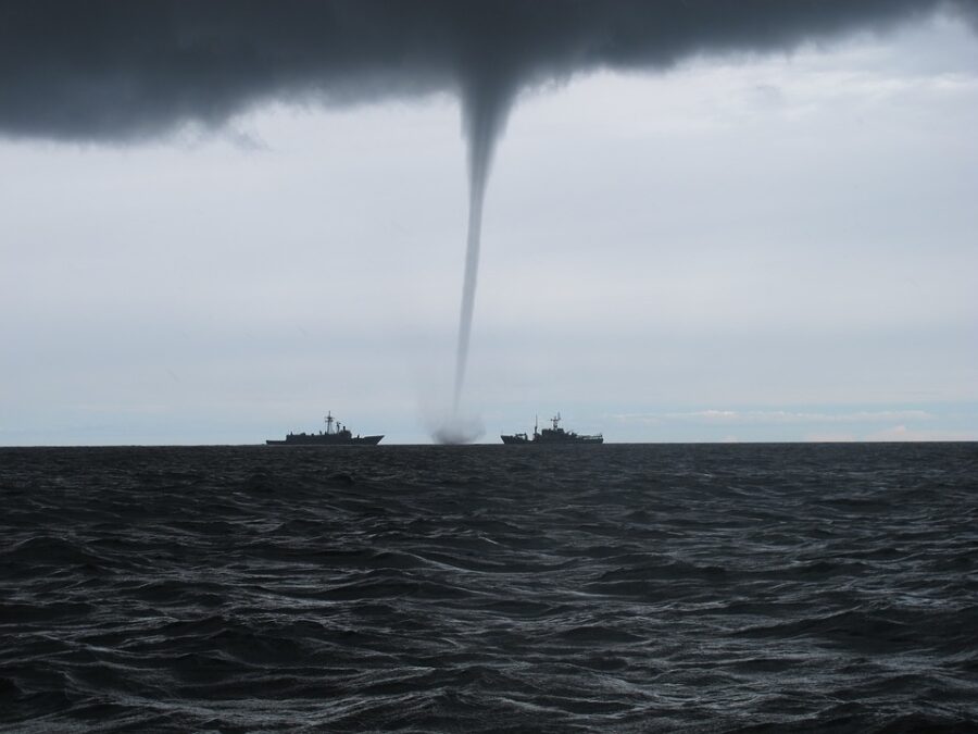
For the most part, non-supercell tornadoes are smaller, weaker, and shorter in duration than their counterparts. Common examples are landspouts and waterspouts.
Mostly born out of thunderstorms, the intense spinning winds may reach as high as 300 miles per hour, occasionally more. The frequently noted phenomenon of a tornado putting straw through a tree is not an urban legend. That’s how powerful these storms can be.
The size and intensity of tornadoes vary a great deal. Some can leave swaths of destruction a mile wide and 50 miles long. Others are smaller and more focused. It’s not uncommon to see photos that look like a lawnmower went through a neighborhood, completely leveling one house while the one next door appears relatively untouched. Some storms last a long time, though most are only on the ground for roughly 15 minutes, which is still time to cause plenty of damage.