Earthquakes: Risk Of A Big San Andreas Quake Now 3 Times More Likely
Scientists are working to predict Earthquakes and save lives, but can they? We have the answer.
This article is more than 2 years old
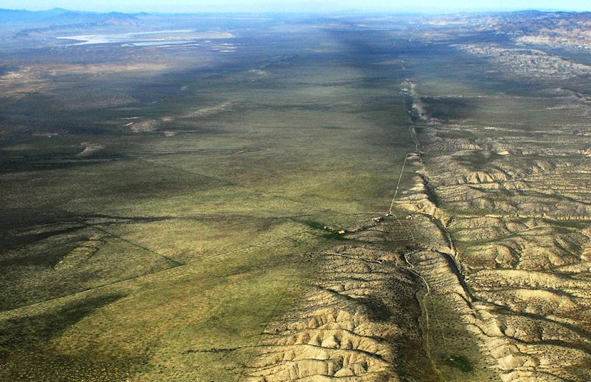
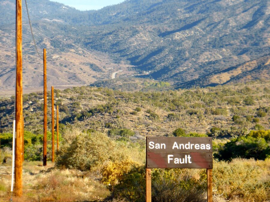
Scientists have been predicting that a massive quake along the San Andreas fault, colloquially named “the big one”, will hit California for years. No one has known when it hit, only that it will and that its effects will be devastating. Now the chances that it’ll hit soon have just gone up. Way up.
According to a new study published this week in the Bulletin of the Seismological Society of America, the smaller Ridgecrest earthquakes which rocked California in 2019 have now made “the big one” three times more likely. The big one would be a quake along California’s massive San Andreas fault line and according to their data there is now a 1.15% chance that it’ll happen some time in the next year. Last year the odds were only 0.35%.
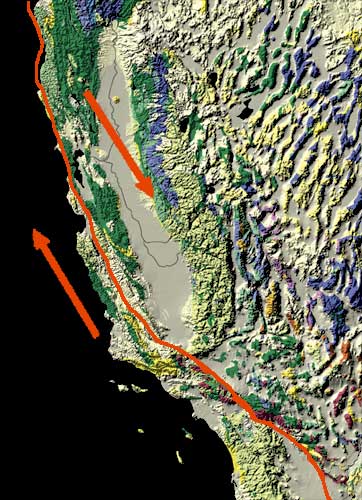
The San Andreas fault runs roughly the entire length of California. A quake of even a magnitude of 7.8 along that fault is predicted to cause thousands of deaths and displace millions from their homes.
Meanwhile those smaller quakes last year have also increased the chances of a smaller (but still really big) quake along the Garlock fault some time in the next year to 2.3%. Such a quake would be a 7.5 on the richter scale or greater. The Garlock fault runs for 160 miles along the Mojave Desert. Should Garlock happen the risk of a San Andreas quake will rocket even higher. Ross Stein, a coauthor of the study says, “the Ridgecrest earthquake brought the Garlock fault closer to rupture. If that fault ruptures — and it gets within about 25 miles of the San Andreas — then there’s a high likelihood, maybe a 50/50 shot, that it would immediately rupture on the San Andreas.”
Huge 6.4 Quake Rocks Nevada, Epicenter In A Spot That Drives Conspiracy Theorists Wild – May 15, 2020
Nevada was rocked by a huge 6.4 magnitude earthquake in the early morning hours on May 15, 2020. The quake was centered near Tonopah, Nevada and as of this moment, significant aftershocks are ongoing.
So far no major damage or injuries have been reported as a result from the quake. However a 6.4 magnitude earthquake is large enough to do major damages. Given that this one hit in a fairly remote area, though, that may have been avoided. The city of Tonopah is home to around 3,000 people.
The Esmerelda County Sheriff’s Office has reported some damage to highway US95. See pictures of that below…
Tonopah, Nevada is also the location of the Tonopah Test Range, a site of interest for Area 51 conspiracy theorists. The Tonopah Test Range is a restricted military facility believed to house and test classified, experimental military aircraft. Tonopah itself is only around 70 miles away from the infamous Area 51 at Groom Lake, Nevada.
Utah Quake – March 18, 2020
Utah was hit by a 5.7 magnitude earthquake on the morning of Wednesday March 18, 2020. The shaking started at around 7 a.m. according to data from the U.S. Geological Survey.
The quake’s epicenter was near Magna, Utah. Magna is one of the outer suburbs of Salt Lake City, which means the shaking was felt in the state’s most populated center. No injuries have been reported so far, but around 32,000 people lost power.
This is the largest earthquake to hit Utah since 1992. Quakes of this size are expected to hit this particular area every 50 years or so.
Here’s a video a mom took right when it happened…
Here’s a video taken by someone inside a store when the quake hit…
And here’s another photo of the aftermath…
The state is currently experiencing aftershocks. You can see one of them hit newscaster in the video below…
The Science Of Earthquakes
Didja feel that? Thankfully that question is not asked often across the United States. But it is asked often enough. Our planet is in a constant state of shift and depending on where you are located, this shifting will be felt. We call this natural occurrence an earthquake and even though you may not be in an area where they occur with frequency, they happen, and they will continue to happen. Scientists are working to predict Earthquakes and save lives, but can they? We have the answer.
What is an Earthquake?
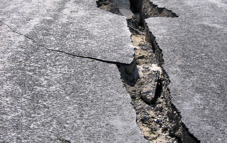
An earthquake is what happens when two blocks of the earth suddenly shift or slip past one another.
Our earth has four major layers. These are the inner core, the outer core, the mantle, and the crust. It is the mantle and the top part of the crust that make the surface of the planet. We call this upper-crust the lithosphere.
This surface isn’t all one piece, it has many pieces. Think of it like puzzle pieces. These puzzle pieces move constantly, bumping into one another and sliding past one another. These pieces are called tectonic plates and their edges are called plate boundaries. These plate boundaries, their edges, have faults along them. It is along these faults where most of the earthquakes occur.
As the earth moves, these plates continue to shift. What happens, though, is the rough edges of the plates get stuck while the rest continues to move. The energy used to move these plates around is now being stored up because of the plates sticking.
When these plates finally break apart, the stored-up force is released. This force or energy will then radiate outward in all directions from the fault creating seismic waves. Think of it as ripples on water. As these waves move outward, they eventually reach the surface, causing the shaking we feel and depending on how much of a shift the tectonic plates move, it will give us an indication as to how strong of an earthquake we get.
Below the earth’s surface, where the earthquake starts is called the hypocenter or the focus. Moving vertically above the hypocenter is where we feel the strongest part of the earthquake and that is called the epicenter.
The Three Parts of an Earthquake
For the most part, there are three parts to an earthquake.
- Foreshock -A foreshock occurs before the main event. It will present as a smaller quake or quakes that eventually lead to the big earthquake. The timing behind the foreshock leading up to the bigger one can be difficult to determine as a big quake can follow the foreshock by minutes, hours, days and even longer. The 2002 Sumatra earthquake, a 7.3 giant, has largely been regarded as the foreshock to the Indian Ocean earthquake which happened two years later in 2004.
- Mainshock – The earthquake. The event. This is where the bulk of the damage occurs. The stored energy from the stuck plates is finally released in full, causing the major shake felt around the epicenter. For the most part, a typical earthquake will last in duration between 10 and 30 seconds. On the rare occasion, they may hit a minute. The Indian Ocean earthquake, thankfully rare, was a beast that lasted almost ten minutes.
- Aftershock – As with foreshocks, there really is no timetable as to how many aftershocks will come after the big event. And like foreshocks, they typically appear as much smaller events, though they can still do considerable damage depending on how big the main quake is. Aftershocks have been known to occur minutes after the main event, hours, days and months.
Seismographs and the Richter Scale
It’s often said: the bigger the better. But in this case, bigger is definitely not better when it comes to earthquakes. There are many smaller earthquakes we can’t feel and they happen all the time. But if we can’t feel them, how do we know they are happening? And when we do get the bigger ones, how do we know just how big they measure?
Scientists use a seismograph to measure earthquakes. These instruments are basically a large base or frame held in a very solid position. They have a mass attached to it, a large mass so it won’t move. This seismograph will have a roll of paper and a pencil-type instrument also attached to record the ground shaking. As the ground shakes, the frame shakes, causing the pencil to move up and down. The seismograph is used to determine three things: the magnitude or size of the earthquake, the depth or how deep it was, and the location or where the earthquake occurred.
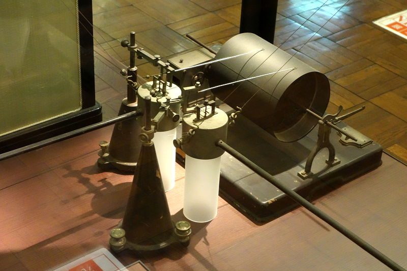
Back in 1935, Charles F. Richter developed a way to measure the intensity of an earthquake. We have used this scale since, though today we use it is used mainly for news reporting as scientists have come up with a different scale that better determines the size of an earthquake based on their seismic moment. The Richter Scale is based on a 1-10 number system, the higher the number, the worse the earthquake is.
Here is a quick glance on the Richter Scale.
- 1.0 – 1.9: A microquake. Nothing is felt at all.
- 2.0 – 2.9: These are minor quakes, rarely felt, though some do.
- 3.0 – 3.9: As with the prior, though you may notice objects moving/shaking.
- 4.0 – 4.9: More noticeable, especially by people inside. Minimal damage and may be felt outside.
- 5.0 – 5.9: Everyone can feel these. Damage not too significant unless buildings are of a poor construct.
- 6.0 – 6.9: Getting strong. Well-built structures will feel the damage. Strong shaking at the epicenter.
- 7.0 – 7.9: This is major and will cause damage to most buildings. Felt across a large distance.
- 8.0 – 8.9: Major damage to buildings and structures. Felt over extremely large regions.
- 9.0 and greater: Near-total destruction or total. Permanent changes can be seen in topography.
As technology advanced, scientists were better able to measure earthquakes. And while the Richter Scale is still widely used, scientists also use the moment magnitude scale to help determine the strength of an earthquake. This scale uses more mathematics than the original Richter Scale and is actually the most common form of measuring earthquakes among scientists.
How Do We Monitor Earthquakes?
Across the United States and scattered across the globe, scientists use various seismographs to record seismic data. These instruments are very sensitive as they record ground motion and are synchronized by time to their seismograms can be analyzed systematically. So with all these seismographs and the new technology afforded to scientists, how does this better out chances to actually predict the big one?
Can We Predict Earthquakes?
Can we actually predict earthquakes? The answer is… maybe? But let’s take a deeper look as to why we can or maybe we can’t.
It’s not like scientists aren’t trying, they are. They have tried to link natural factors that occur before a large earthquake. They look at the increased radon in local water supplies, changes in electromagnetic activity, they look at rising groundwater levels, they even look for odd animal behavior. But the simple fact is they can’t determine the energy released from the plate shifting that goes one beneath the earth’s surface.
Predicting With Foreshocks
Daniel Trugman, a seismologist at the Los Alamos National Laboratory led a recent study on earthquake prediction. “One of the biggest questions in earthquake seismology is how earthquakes get started,” Trugman told the LA Times. The study seismologists took a look at earthquakes between 2008 and 2017 in Southern California of a magnitude of at least 4.0 and found 72% follow foreshocks. The study also noted that “Elevated foreshock activity is pervasive in Southern California.”
So, does this mean these foreshocks are a precursor to the big one? Coauthor of the study and assistant professor of geophysics at Caltech Zachary Ross responded, “It is surprising. It’s important for understanding the physics of earthquakes. Are they silent until this big event? Or is there a weakening process of the fault, or some evidence that the fault is changing before this larger event?”
Warning Signs
The one thing they have been able to do to get a better read on earthquakes is forecast. Scientists try to forecast a big event by looking at what’s happening beneath the surface. They can see how fast the tectonic plates are slipping along fault lines. They can estimate what type of energy this slippage may generate thus allowing them to say what type of magnitude earthquake could be on its way. But these forecasts can be off by years. Dozens of years even. But still, there is hope. “We are definitely moving toward forecasting that is statistical in nature,” Trugman said.
The scientists simulated earthquakes in their lab and found there were always smaller quakes that appeared before the big one. “It’s never just silent until the final failure,” Ross said about the simulated quakes. These results definitely suggest that smaller quakes precede the more moderate to large ones. “It’s hard to imagine this huge fault that stays completely silent until a single point just happens to start failing,” Ross said. “Physically, that seems a little difficult to imagine.”
Predicting and forecasting can have its drawbacks. In fact, it can lead you to some jail time on manslaughter charges. In April 2009, Italy was victim to the L’Aquila earthquake that took 300 lives. Because of this, 7 people (6 of them scientists) were brought up on charges of manslaughter for failing to predict the earthquake. Prosecutors of this case said that these scientists gave an ineffective and generic assessment of the risk. Not only were the scientists found guilty, but the court also ordered the Italian authorities to pay $10 million in damages.
ShakeAlert
The west coast of the United States has an earthquake early warning system called ShakeAlert. This system does not predict an earthquake, but it does detect earthquakes. The ShakeAlert can do this so swiftly that an alert can reach people before the shaking arrives. This ShakeAlert system is being used by many types of entities that include hospitals, transportation systems, utilities, and educational systems.
How Big Can Earthquakes Get?
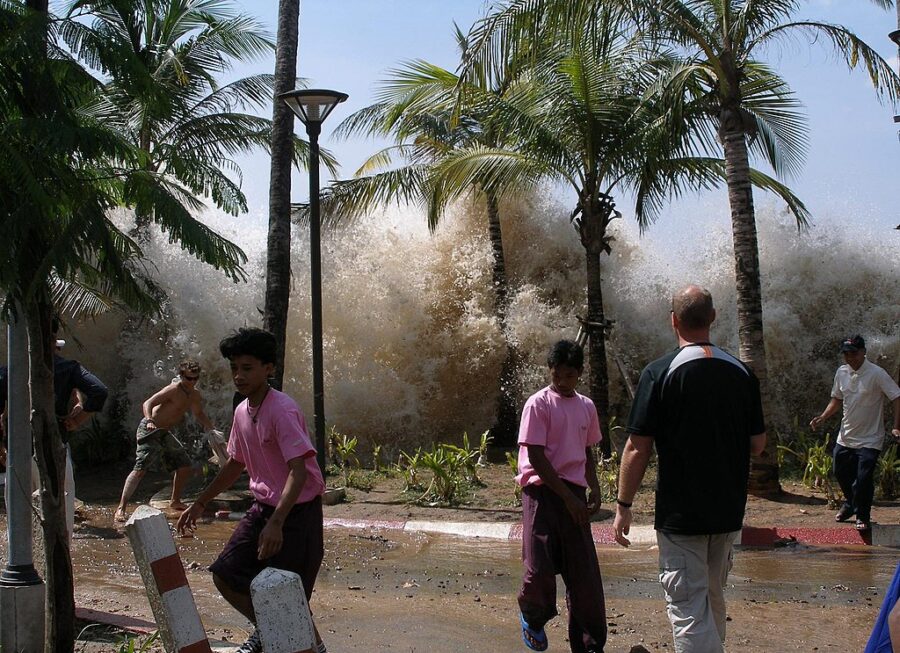
Natural disasters can be devastating. This globe has seen many and unfortunately as long as it spins, natural disasters are sure to follow. When it comes to earthquakes, we have seen some big ones. And not only is the damage from the earthquake devastating but earthquakes are also the cause of another natural disaster, the tsunami.
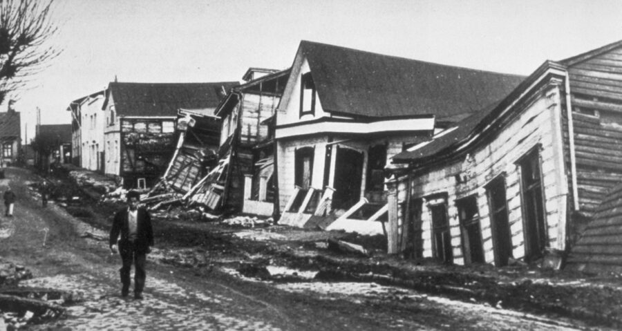
Valdivia, Chile May 22, 1960 – 9.5 magnitude: This is the largest earthquake on record. It killed 1,655 people, injuring over 3,000 and displaced over two million. It caused over $550 million in damages and the tsunami it created caused death as far away as Hawaii, the Philippines, and Japan.
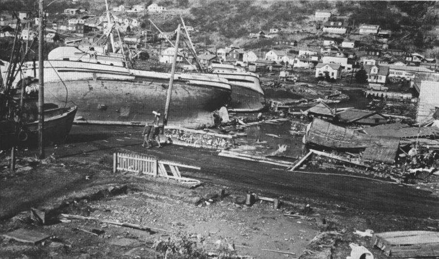
Prince William Sound, Alaska March 28, 1964 – 9.2 Magnitude: As large as this quake was, it caused significantly less damage and loss of life. 128 lives were lost and the damage totaled $311 million. This quake lasted over four and a half minutes which caused a tsunami that took those 128 lives.
Speaking of tsunami’s, another Alaskan quake, this one located along the Fairweather Fault in the Alaskan Panhandle, caused rock to fall from high above the northeastern shore of Lituya Bay. It dropped from approximately 3,000 feet and its force hitting the water caused a tsunami that hit heights of 1,720 feet, wiping out everything in its path.
Sumatra, Indonesia, December 26, 2004 – 9.1 magnitude: This one is also known as the Indian Ocean earthquake and tsunami, causing untold damage and loss of life. Over 227,900 people died and over 1.7 million were displaced over 14 different countries.
With these scary big numbers in terms of magnitude, could we ever see one that reaches 10.0? Theoretically, it is possible but Toru Matsuzawa, a professor at Japan’s Tohoku University, told Japan Times he isn’t sure. “The estimate does not mean that a magnitude 10 quake will inevitably happen. If it happens, it would take place around once every 10,000 years.” He also said one way it could happen is if the 3,000 combined km’s of faults from the Kuril-Kamchatka Trench to the Japan trench moved by 60 meters. Let’s hope that never happens!
Most Frequent Earthquake Regions
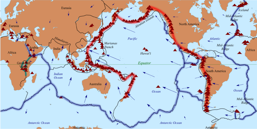
The Ring of Fire is an area comprised of the basin of the Pacific Ocean. This is significant in earthquake terms as this region produces 90% of the world’s earthquakes with 81% of them being the world’s largest. The plate tectonics in this region are the cause of so many earthquakes because they all converge here.
The west coast of the United States is also a big earthquake magnet. There are two plates in California, the Pacific Plate and the North American Plate, that has one of the longest fault lines, the infamous San Andreas fault. This fault is 650 miles long and goes to depths of at least 10 miles. There is a lot of movement along this fault line, as evidenced by the 1906 San Francisco earthquake and more recently the 1989 Loma Prieta earthquake.
With the ever-shifting globe, earthquakes are not something we can avoid. But hopefully, with detection, we may be able to warn people of what’s to come and that may be all that’s needed to save lives. At this point, that is all we can ask for.