Typhoon Haishen: Watch The Storm Wreak Havoc From Space
The severe storm has already affected South Korea and Japan.
This article is more than 2 years old
Typhoon Haishen, known in the Philippines as Typhoon Kristine, is the first super typhoon of the 2020 Pacific typhoon season. The severe storm has already hit the Korean peninsula and Japan, causing serious damage and drenching.
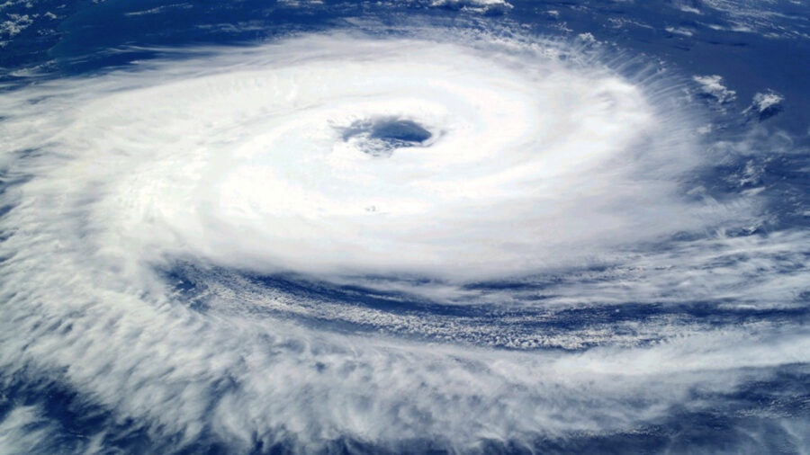
You can view the trajectory of Typhoon Haishen (as well as the smaller typhoon, Typhoon Maysak) in the embedded tweet below. These images come from the Himawari 8 satellite. This is a powerful representation of the size of the super typhoon.
There have also been at least four deaths attributed to Typhoon Haishen. Two were killed in Japan and two were killed in South Korea. Over a hundred citizens were reported as injured from the typhoon in Japan, and four Japanese citizens are missing after a mudslide caused by the typhoon in Miyazaki Prefecture. More than 300,000 homes in Japan have lost power as a result of Typhoon Haishen.
In South Korea, Typhoon Haishen has displaced 3,100 people and at least 75,000 houses have been reported without power. five injuries connected with the typhoon have been reported. There are also two missing persons that are also connected to the storm.
This news report from Reuters shows some of the strong winds that lashed Japan and damaged a large portion of the country:
Typhoon Haishen began to form on August 29. It was originally a disorganized tropical disturbance located a few hundred miles northeast of Guam. It quickly began to organized and in two days it became Tropical Depression 11W. This tropical depression almost immediately intensified into a tropical storm and was given the name Haishen. By September 3, Haishen had gained a pinhole eye and underwent an eyewall replacement cycle. The cycle completed very quickly and the storm continued to intensify. It reached peak intensity on September 4 and was designated a Category 4-equivalent super typhoon.
As Typhoon Haishen approached the Southern Ryukyu Islands of Japan, it was downgraded to a category 2 typhoon. Mandatory evacuation orders were in effect for western Japan. Haishen made landfall in Ulsan, South Korea on September 7 around 09:00 KST. It had 10-minute maximum sustained winds at 85 mph. Shortly after, Haishen entered the Sea of Japan as a high-end tropical storm.
Even a day after Typhoon Haishen, you could still see incredibly strong waves bashing up against the Japanese coastline, as evidenced by this video:
The storm has also hit and affected North Korea. Widespread flooding occurred in the country and military personnel were dispatched in order to aid in reconstruction efforts. Due to the state of North Korea, we have not been given any injury or death reports in relation to the typhoon. All residents in the Tongchon province and many others in the province have been evacuated, and flood warnings are in effect for all rivers, streams, and reservoirs.
Typhoon Haishen is a horrific start to typhoon season and it is possible that an even worse storm will form before the season is over. We will keep updated on any significant news regarding Haishen.