Mars Displays Strange Saucer-Shaped Dunes In Eerie NASA Photos
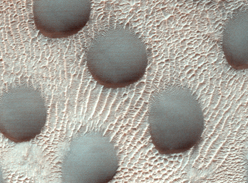
NASA's HiRise camera shows that Mars has eerie circular dunes on its surface.
Since astronomers first looked up into the dark sky and witnessed the bright red dot that is Mars, scientists have been interested in learning as much as they can about our neighboring planet. We’ve come a long way since 1961 when the first human entered space, and while NASA has plans to build homes on the red planet someday, only robots have touched ground on mars, collecting samples and taking pictures for us to study. Now, NASA is learning even more about our red neighbor and has captured new photographs showing eerie saucer-shaped “Mars dunes” clustered over the desert world’s surface.
The University of Arizona created the HiRise camera (short for High-Resolution Imaging Experiment), and planetary scientists at the school use the large, foil-covered image-capturing telescope to keep an eye on the Martian surface. The HiRise orbits Mars and is controlled by the U of A from 118.87 million miles away. The camera is able to capture subjects as small as a kitchen table, and it looks like something from straight out of E.T.
It was with this exemplary scientific camera that scientists were able to capture images of the almost perfectly circular Mars dunes huddled together on the planet’s surface.
While Mars is a planet that is covered in dunes, mounds of sand in perfect circular formations are very strange and unusual. However, the images show that these dunes are not absolute circles and seem to be slightly asymmetrical, with steep slip faces appearing on the southern ends. U of A scientists explained that even though the winds on the planet are variable, these dips indicate that the sand on the dunes often moves toward the south.
U of A shared two images of Mars’ circular dunes with the public—one image that shows the dunes without frost and one image that shows what the dunes look like when they’re covered in frost. To give an idea of how much space these pictures cover, every pixel in the linked images is equivalent to about 25 centimeters (that’s 9.8 inches to our American friends).
The defrosted Mars dunes image was taken by HiRise on November 22, 2022, at a latitude of 42.505 degrees and a longitude of 67.076 degrees while the camera orbited the red planet on the Mars Reconnaissance Orbiter (MRO) spacecraft. Planetary scientists are using this series of images to observe how frost melts at the end of winter on our neighboring planet.
The HiRise camera has recorded an extensive collection of Mars dunes that range in variety and shape. These images help scientists better understand the weather conditions on Mars, including the typical wind patterns.
The more we learn about the Red Planet, the more we can conclude the possibility that Mars once supported live beings. In fact, scientists have discovered what might have been precious gemstones on Mars, indicating that before it was covered in desert sand dunes, the planet may have been full of water. At one point, Mars was likely an ocean world with so much water that it could have sustained life.


